


Descrição de BackCountry Navigator XE: Outdoor GPS App (New)
Welcome to the next generation of a product for exploring the outdoors on your own terms, using offline topo maps and GPS on your smartphone.
You can also subscribe to the XE List to get notified of status, updates, and deals.
While many of the goals of the new app are the same, we are hoping to achieve a number of goals with the new platform:
Cross-Platform
The original BackCountry Navigator PRO is only available on Android. We will be bringing BackCountry Navigator XE to Android, iOS and the web.
The corresponding app for iOS will be launched through TestFlight
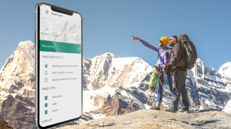
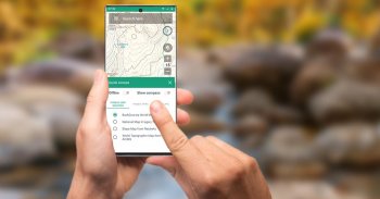
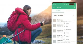
Planning In The Cloud
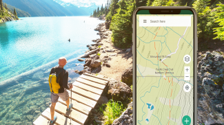
The website bcnavxe.com is the web interface for BackCountry Navigator XE. With it you can plot points, routes, and boundaries for trips, and download them on demand in the mobile app. You can push trips created in the mobile app to the cloud as well for reviewing or sharing.
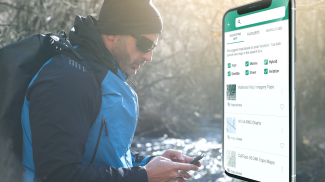
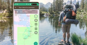
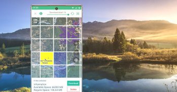
Easy Grid Based Download of Maps
You can try out a simpler approach for downloading and organizing offline maps, choosing large squares at a time. Visualize what you have and what you need.
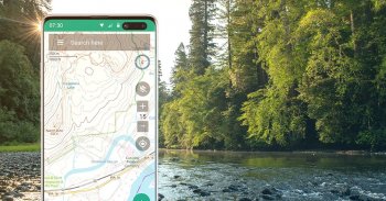
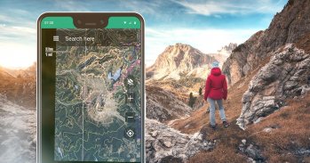
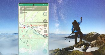
Vector Topo Maps for the World
Vector topo maps for the world hold the promise of crisp multilevel detail, with the ability to download large chunks of the earth's surface in a quick, compact operation. The BackCountry topo map for the world can be viewed in this app and on bcnavxe.com, with an easy process to install them in large blocks.
SALE: 5 and 10 year plans now available for a limited time at bcnavxe.com.
Use coupon SUB2020 to save even more before the end of the month.
If you are looking for an already proven and established product, also consider BackCountry Navigator PRO. Support and development of that app continues on a parallel track.
https://play.google.com/store/apps/details?id=com.crittermap.backcountrynavigator.license
Bem-vindo à próxima geração de um produto para explorar o exterior em seus próprios termos, usando mapas topográficos offline e GPS no seu smartphone.
Você também pode se inscrever na lista XE para receber notificações de status, atualizações e ofertas.
Embora muitos dos objetivos do novo aplicativo sejam os mesmos, esperamos alcançar vários objetivos com a nova plataforma:
Plataforma cruzada
O BackCountry Navigator PRO original está disponível apenas no Android. Trazeremos o BackCountry Navigator XE para Android, iOS e Web.
O aplicativo correspondente para iOS será lançado pelo TestFlight
Planejando na nuvem
O site bcnavxe.com é a interface da web do BackCountry Navigator XE. Com ele, você pode traçar pontos, rotas e limites para viagens e fazer o download sob demanda no aplicativo móvel. Você pode enviar viagens criadas no aplicativo móvel para a nuvem, além de revisar ou compartilhar.
Download fácil de mapas com base em grade
Você pode tentar uma abordagem mais simples para baixar e organizar mapas offline, escolhendo quadrados grandes por vez. Visualize o que você tem e o que precisa.
Mapas vetoriais para o mundo
Os mapas topográficos de vetor para o mundo cumprem a promessa de detalhes nítidos em vários níveis, com a capacidade de baixar grandes pedaços da superfície da Terra em uma operação rápida e compacta. O mapa topo do BackCountry para o mundo pode ser visto neste aplicativo e em bcnavxe.com , com um processo fácil de instalá-los em grandes blocos.
VENDA: planos de 5 e 10 anos agora disponíveis por tempo limitado em bcnavxe.com.
Use o cupom SUB2020 para economizar ainda mais antes do final do mês.
Se você estiver procurando por um produto já comprovado e estabelecido, considere também BackCountry Navigator PRO. O suporte e o desenvolvimento desse aplicativo continuam em uma trilha paralela.
https://play.google.com/store/apps/details?id=com.crittermap.backcountrynavigator.license
BackCountry Navigator XE: Outdoor GPS App (New) - Versão 2.8.1
(03-09-2023)BackCountry Navigator XE: Outdoor GPS App (New) - Informação APK
Versão APK: 2.8.1Pacote: com.crittermap.backcountrynavigator.xeÚltima Versão de BackCountry Navigator XE: Outdoor GPS App (New)
Apps na mesma categoria
Também podes gostar...


